
Make a donation
Closter topographic map
Click on the map to display elevation.
Make a donation
Closter
The topography gave a sense of isolation and protection, tucked behind the highest point of the Palisades and protected by limited access. Alternatively, sources indicate that the name derives from an early settler named Frederick Closter who is said to have been granted the land in the area in the 1600s.
Make a donation
About this map
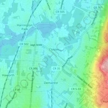
Name: Closter topographic map, elevation, terrain.
Location: Closter, Bergen County, New Jersey, 07624, United States (40.95748 -74.00184 40.98434 -73.93435)
Average elevation: 32 m
Minimum elevation: 3 m
Maximum elevation: 165 m
Make a donation
Other topographic maps
Click on a map to view its topography, its elevation and its terrain.
Make a donation
River Edge
United States > New Jersey > Bergen County > River Edge > River Edge
Average elevation: 21 m
Make a donation
Make a donation
New Bridge
United States > New Jersey > Bergen County > New Milford > New Bridge
Average elevation: 19 m
Wallington
United States > New Jersey > Bergen County > Wallington > Wallington
Average elevation: 23 m
Warren Point
United States > New Jersey > Bergen County > Fair Lawn > Warren Point
Average elevation: 22 m
Make a donation
Ridgefield
United States > New Jersey > Bergen County > Ridgefield > Ridgefield
Average elevation: 24 m
Make a donation