
Thank you for supporting this site ❤️
Make a donation
Make a donation
Oetinghauser Heide topographic map
Click on the map to display elevation.
Thank you for supporting this site ❤️
Make a donation
Make a donation
About this map
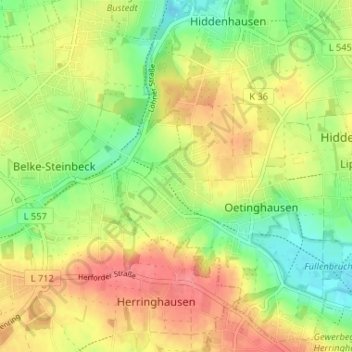
Name: Oetinghauser Heide topographic map, elevation, terrain.
Average elevation: 99 m
Minimum elevation: 65 m
Maximum elevation: 133 m
Thank you for supporting this site ❤️
Make a donation
Make a donation
Other topographic maps
Click on a map to view its topography, its elevation and its terrain.
Lippinghausen
Deutschland > Nordrhein-Westfalen > Kreis Herford > Hiddenhausen
Average elevation: 97 m
Eilshausen
Deutschland > Nordrhein-Westfalen > Kreis Herford > Hiddenhausen
Eilshausen war eine Siedlung, die sich zu einem westfälischen Angerdorf entwickelte. Es ist zu vermuten, dass die Höfe einmal dicht am Wiesenbach gelegen haben, da die früher hier betriebene Spinnerei eine feuchte Luft erfordert. Später sind sie höher hinaus und an andere Ortsstellen verlegt worden. Nach…
Average elevation: 105 m