
Thank you for supporting this site ❤️
Make a donation
Make a donation
Kalmar County topographic map
Click on the map to display elevation.
Thank you for supporting this site ❤️
Make a donation
Make a donation
About this map
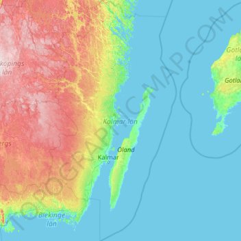
Name: Kalmar County topographic map, elevation, terrain.
Location: Kalmar County, Sweden (55.91412 15.33726 58.14241 17.51977)
Average elevation: 62 m
Minimum elevation: -3 m
Maximum elevation: 365 m
Thank you for supporting this site ❤️
Make a donation
Make a donation
Other topographic maps
Click on a map to view its topography, its elevation and its terrain.
Thank you for supporting this site ❤️
Make a donation
Make a donation
Skövde
Sweden > Västra Götaland County
Skövde has a maritime-continental hybrid climate. The town is influenced by being in the slope of a hill, which leads to warmer overnight lows than in Skara on the western side of the same higher area. In July 2018, Skövde recorded a 22 °C (72 °F) mean during the 2018 European heat wave. This makes it one…
Average elevation: 181 m
Thank you for supporting this site ❤️
Make a donation
Make a donation
Thank you for supporting this site ❤️
Make a donation
Make a donation
Thank you for supporting this site ❤️
Make a donation
Make a donation
Thank you for supporting this site ❤️
Make a donation
Make a donation
Thank you for supporting this site ❤️
Make a donation
Make a donation
Thank you for supporting this site ❤️
Make a donation
Make a donation
Thank you for supporting this site ❤️
Make a donation
Make a donation
Thank you for supporting this site ❤️
Make a donation
Make a donation