
Thank you for supporting this site ❤️
Make a donation
Make a donation
Belfast topographic map
Click on the map to display elevation.
Thank you for supporting this site ❤️
Make a donation
Make a donation
About this map
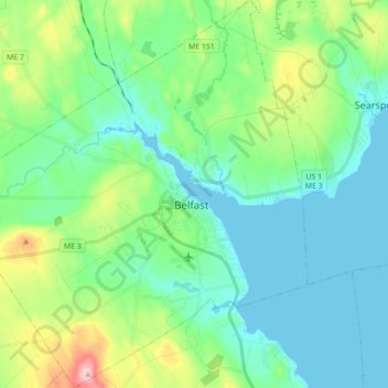
Name: Belfast topographic map, elevation, terrain.
Location: Belfast, Waldo County, Maine, 04915, United States (44.36743 -69.11828 44.49202 -68.95553)
Average elevation: 52 m
Minimum elevation: -1 m
Maximum elevation: 223 m
Thank you for supporting this site ❤️
Make a donation
Make a donation
Other topographic maps
Click on a map to view its topography, its elevation and its terrain.