
Thank you for supporting this site ❤️
Make a donation
Make a donation
Saugues topographic map
Click on the map to display elevation.
Thank you for supporting this site ❤️
Make a donation
Make a donation
Saugues
The municipality lies in the Margeride mountains, with its highest point reached at the summit of Montchauvet at an altitude of 1,485 meters.
Thank you for supporting this site ❤️
Make a donation
Make a donation
About this map
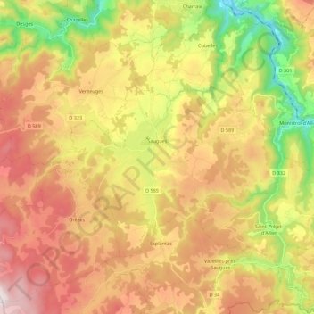
Name: Saugues topographic map, elevation, terrain.
Average elevation: 1,012 m
Minimum elevation: 540 m
Maximum elevation: 1,476 m
Thank you for supporting this site ❤️
Make a donation
Make a donation
Other topographic maps
Click on a map to view its topography, its elevation and its terrain.
Thank you for supporting this site ❤️
Make a donation
Make a donation
Peyredeyre
France > Auvergne-Rhône-Alpes > Haute-Loire > Chaspinhac > Peyredeyre
Average elevation: 739 m
Château abbatial
France > Auvergne-Rhône-Alpes > Haute-Loire > Le Monastier-sur-Gazeille > Artaud
Average elevation: 938 m