
Thank you for supporting this site ❤️
Make a donation
Make a donation
Mendocino County topographic map
Click on the map to display elevation.
Thank you for supporting this site ❤️
Make a donation
Make a donation
About this map
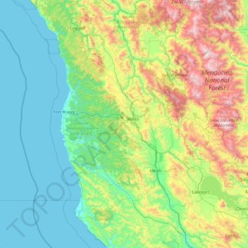
Name: Mendocino County topographic map, elevation, terrain.
Location: Mendocino County, California, United States (38.75812 -124.13489 40.00247 -122.81767)
Average elevation: 486 m
Minimum elevation: 0 m
Maximum elevation: 2,241 m
Thank you for supporting this site ❤️
Make a donation
Make a donation
Other topographic maps
Click on a map to view its topography, its elevation and its terrain.
Allensworth
United States > California > Tulare County
Allensworth sits at an elevation of 213 feet (65 m), the same elevation as the huge and historically important Tulare Lake shore when it was full. The community is located in the ZIP Code 93219 and in the area code 661.
Average elevation: 63 m
Thank you for supporting this site ❤️
Make a donation
Make a donation