
Noroeste topographic map
Interactive map
Click on the map to display elevation.
About this map
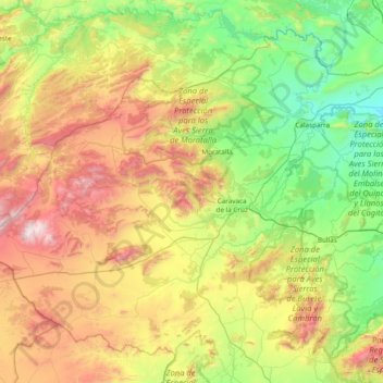
Name: Noroeste topographic map, elevation, terrain.
Location: Noroeste, Región de Murcia, España (37.86847 -2.34441 38.38129 -1.57900)
Average elevation: 836 m
Minimum elevation: 222 m
Maximum elevation: 2,003 m
Other topographic maps
Click on a map to view its topography, its elevation and its terrain.
Cehegín
España > Región de Murcia > Noroeste > Cehegín
Cehegín, Noroeste, Región de Murcia, 30430, España
Average elevation: 724 m