
Montfranc topographic map
Interactive map
Click on the map to display elevation.
About this map
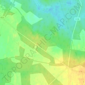
Name: Montfranc topographic map, elevation, terrain.
Average elevation: 126 m
Minimum elevation: 111 m
Maximum elevation: 142 m
Other topographic maps
Click on a map to view its topography, its elevation and its terrain.
Le Bourg
France > Centre-Val de Loire > Loir-et-Cher > Pierrefitte-sur-Sauldre
Le Bourg, Pierrefitte-sur-Sauldre, Romorantin-Lanthenay, Loir-et-Cher, Centre-Val de Loire, France métropolitaine, 41300, France
Average elevation: 124 m
Le Reuilly
France > Centre-Val de Loire > Loir-et-Cher > Pierrefitte-sur-Sauldre > Le Reuilly
Le Reuilly, Pierrefitte-sur-Sauldre, Romorantin-Lanthenay, Loir-et-Cher, Centre-Val de Loire, France métropolitaine, 41300, France
Average elevation: 125 m