
Thank you for supporting this site ❤️
Make a donation
Make a donation
Kuala topographic map
Click on the map to display elevation.
Thank you for supporting this site ❤️
Make a donation
Make a donation
About this map
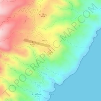
Name: Kuala topographic map, elevation, terrain.
Location: Kuala, Maui County, Hawaii, United States (21.13503 -156.73059 21.13513 -156.73049)
Average elevation: 122 m
Minimum elevation: 0 m
Maximum elevation: 305 m
Thank you for supporting this site ❤️
Make a donation
Make a donation
Other topographic maps
Click on a map to view its topography, its elevation and its terrain.
Thank you for supporting this site ❤️
Make a donation
Make a donation
Thank you for supporting this site ❤️
Make a donation
Make a donation
Kahoolawe
United States > Hawaii > Maui County
Kahoʻolawe (Hawaiian: [kəˈhoʔoˈlɐve]), anglicized as Kahoolawe (/kɑːˌhoʊoʊˈlɑːweɪ, -veɪ/), is the smallest of the eight main volcanic islands in the Hawaiian Islands. Kahoʻolawe is located about seven miles (11 km) southwest of Maui and also southeast of Lānaʻi, and it is 11 mi (18 km) long…
Average elevation: 70 m
Thank you for supporting this site ❤️
Make a donation
Make a donation