Geolocate

Alor Island topographic map

Interactive map

Click on the map to display elevation.

About this map

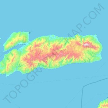
Name: Alor Island topographic map, elevation, terrain.

Location: Alor Island, East Nusa Tenggara, Indonesia (-8.45960 124.33779 -8.12245 125.14266)

Average elevation: 149 m

Minimum elevation: 0 m

Maximum elevation: 1,737 m

Other topographic maps

Click on a map to view its topography, its elevation and its terrain.

Timor

Indonesia > East Nusa Tenggara

Average elevation: 84 m

Golo Desat

Indonesia > East Nusa Tenggara > Golo Desat

Average elevation: 615 m

Sumba

Indonesia > East Nusa Tenggara

Average elevation: 81 m

Lembata

Indonesia > East Nusa Tenggara

Average elevation: 975 m

Adonara

Indonesia > East Nusa Tenggara > Adonara

Average elevation: 93 m

Maumere

Indonesia > East Nusa Tenggara > Maumere

Average elevation: 53 m