
Thank you for supporting this site ❤️
Make a donation
Make a donation
Calau topographic map
Click on the map to display elevation.
Thank you for supporting this site ❤️
Make a donation
Make a donation
Calau
In Calau steht die Napoleoneiche mit einem Brusthöhenumfang von 7,30 m (2016).
Thank you for supporting this site ❤️
Make a donation
Make a donation
About this map
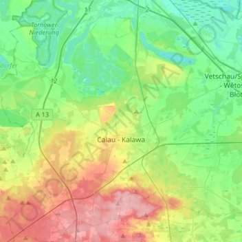
Name: Calau topographic map, elevation, terrain.
Location: Calau, Oberspreewald-Lausitz, Brandenburg, 03205, Deutschland (51.67841 13.79822 51.83892 14.05045)
Average elevation: 83 m
Minimum elevation: 43 m
Maximum elevation: 159 m
Thank you for supporting this site ❤️
Make a donation
Make a donation
Other topographic maps
Click on a map to view its topography, its elevation and its terrain.
Weißag
Deutschland > Brandenburg > Oberspreewald-Lausitz > Luckaitztal
Weißag liegt am südlichen Rand der Calauer Schweiz. Nördlich des Ortes liegen die sogenannten Weißager Berge, deren höchste „Erhebung“ der Spitzberg mit einer Höhe von 144 m ü. NHN ist.
Average elevation: 127 m