Augusta topographic map
Interactive map
Click on the map to display elevation.
About this map
![Augusta topographic map, elevation, terrain](/pub/maps/relation/gcb3/fk79m/thumbnail.jpg)
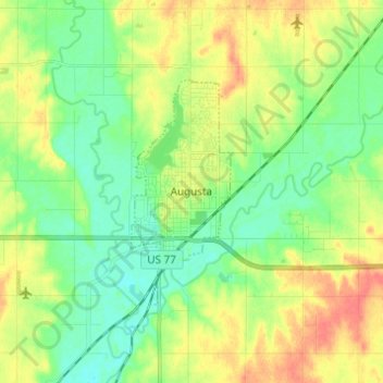
Name: Augusta topographic map, elevation, terrain.
Location: Augusta, Butler County, Kansas, 67010, United States (37.66264 -97.08037 37.71963 -96.95804)
Average elevation: 387 m
Minimum elevation: 368 m
Maximum elevation: 414 m
Other topographic maps
Click on a map to view its topography, its elevation and its terrain.
![Andover topographic map, elevation, terrain](/pub/maps/relation/dwdn/2tntj/icon.jpg)
Andover
United States > Kansas > Butler County
Andover, Butler County, Kansas, United States
Average elevation: 406 m
![Towanda topographic map, elevation, terrain](/pub/maps/relation/k5nh/s6d1h/icon.jpg)
Towanda
United States > Kansas > Butler County > Towanda
Towanda, Butler County, Kansas, United States
Average elevation: 393 m
![Whitewater topographic map, elevation, terrain](/pub/maps/relation/523l/7wx4s/icon.jpg)
Whitewater
United States > Kansas > Butler County
Whitewater, Butler County, Kansas, United States
Average elevation: 419 m
![Augusta Lake topographic map, elevation, terrain](/pub/maps/way/lkgt/wtlmb4s/icon.jpg)
Augusta Lake
United States > Kansas > Butler County > Augusta
Augusta Lake, Augusta, Butler County, Kansas, United States
Average elevation: 388 m
![El Dorado topographic map, elevation, terrain](/pub/maps/relation/j1tf/wj5t6/icon.jpg)
El Dorado
United States > Kansas > Butler County
El Dorado, Butler County, Kansas, 67042, United States
Average elevation: 405 m
![Douglass topographic map, elevation, terrain](/pub/maps/relation/9914/d9s18/icon.jpg)
Douglass
United States > Kansas > Butler County
Douglass, Butler County, Kansas, United States
Average elevation: 368 m