
Make a donation
Sahel topographic map
Click on the map to display elevation.
Make a donation
Sahel
Most of Burkina Faso is a wide plateau formed by riverine systems and is called Falaise de Banfora. There are three major rivers, the Red Volta, Black Volta and White Volta, which cuts through different valleys. The climate is generally hot, with unreliable rains across different seasons. Gold and quartz are common minerals found across the country, while manganese deposits are also common. The dry season is usually from October to May and rains are common during the wet season from June to September. The soil texture is porous and hence the yield is also poor. The average elevation is around 200 m (660 ft) to 300 m (980 ft) above mean sea level. Among West African countries, Burkina Faso has the largest elephant population and the country is replete with game reserves. The northern regions are generally arid and usually have scrub land and semi-deserts. The principal river is the Red Volta, that originates in the northern region and drains into Ghana. The areas near the rivers usually have flies like tsetse and similium, which are carriers of sleep sickness and river blindness. The average rainfall in the region is only around 25 cm (9.8 in) compared to southern regions that receive 100 cm (39 in) rainfall.
Make a donation
About this map
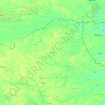
Name: Sahel topographic map, elevation, terrain.
Location: Sahel, Burkina Faso (12.97012 -2.10326 15.08400 1.28470)
Average elevation: 294 m
Minimum elevation: 219 m
Maximum elevation: 979 m
Make a donation
Other topographic maps
Click on a map to view its topography, its elevation and its terrain.
Sahel
The topography of the Sahel is mainly flat; most of the region lies between 200 and 400 meters (660 and 1,310 ft) in elevation. Several isolated plateaus and mountain ranges rise from the Sahel, but are designated as separate ecoregions because their flora and fauna are distinct from the surrounding lowlands.…
Average elevation: 279 m
Make a donation
Make a donation
Make a donation
Make a donation
Make a donation
Make a donation
Make a donation
Make a donation
Make a donation
Make a donation
Make a donation
Make a donation
Make a donation
Make a donation
Make a donation
Make a donation
Make a donation
Make a donation
Make a donation