
Thank you for supporting this site ❤️
Make a donation
Make a donation
Nauen topographic map
Click on the map to display elevation.
Thank you for supporting this site ❤️
Make a donation
Make a donation
Nauen
Im Jahr 1869 erfolgte die Einweihung einer höheren Knabenschule.
Thank you for supporting this site ❤️
Make a donation
Make a donation
About this map
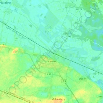
Name: Nauen topographic map, elevation, terrain.
Location: Nauen, Havelland, Brandenburg, Deutschland (52.58613 12.84542 52.64539 13.01349)
Average elevation: 34 m
Minimum elevation: 27 m
Maximum elevation: 52 m
Thank you for supporting this site ❤️
Make a donation
Make a donation
Other topographic maps
Click on a map to view its topography, its elevation and its terrain.
Thank you for supporting this site ❤️
Make a donation
Make a donation
Thank you for supporting this site ❤️
Make a donation
Make a donation