
Rivière Thomonde topographic map
Interactive map
Click on the map to display elevation.
About this map
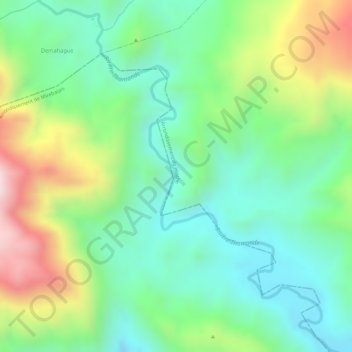
Name: Rivière Thomonde topographic map, elevation, terrain.
Average elevation: 701 m
Minimum elevation: 531 m
Maximum elevation: 1,004 m
Other topographic maps
Click on a map to view its topography, its elevation and its terrain.
Thomonde
Haïti > Département du Centre > Commune Thomonde
Thomonde, Commune Thomonde, Arrondissement de Hinche, Département du Centre, 5130, Haïti
Average elevation: 296 m