
Thank you for supporting this site ❤️
Make a donation
Make a donation
Hite Point topographic map
Click on the map to display elevation.
Thank you for supporting this site ❤️
Make a donation
Make a donation
About this map
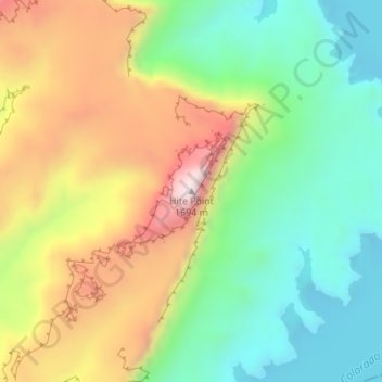
Name: Hite Point topographic map, elevation, terrain.
Location: Hite Point, Garfield County, Utah, United States (37.85967 -110.42973 37.85977 -110.42963)
Average elevation: 1,348 m
Minimum elevation: 1,109 m
Maximum elevation: 1,694 m
Thank you for supporting this site ❤️
Make a donation
Make a donation
Other topographic maps
Click on a map to view its topography, its elevation and its terrain.