
Entlebuch topographic map
Interactive map
Click on the map to display elevation.
About this map
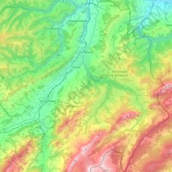
Name: Entlebuch topographic map, elevation, terrain.
Location: Entlebuch, Luzern, Schweiz (46.89277 8.00972 47.03518 8.16484)
Average elevation: 1,066 m
Minimum elevation: 505 m
Maximum elevation: 2,029 m
Other topographic maps
Click on a map to view its topography, its elevation and its terrain.
Schachen
Schweiz > Luzern > Werthenstein
Schachen, Werthenstein, Luzern, 6105, Schweiz
Average elevation: 671 m
Kastanienbaum
Kastanienbaum, Horw, Luzern, 6047, Schweiz
Average elevation: 457 m
Holderchäppeli
Schweiz > Luzern > Schwarzenberg
Holderchäppeli, Schwarzenberg, Luzern, 6013, Schweiz
Average elevation: 867 m
Tschädigen
Tschädigen, Meggen, Luzern, 6045, Schweiz
Average elevation: 534 m
Richenthal
Schweiz > Luzern > Richenthal
Richenthal, Reiden, Luzern, 6260, Schweiz
Average elevation: 583 m