
Make a donation
East Kingston topographic map
Click on the map to display elevation.
Make a donation
About this map
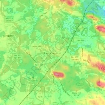
Name: East Kingston topographic map, elevation, terrain.
Average elevation: 38 m
Minimum elevation: 1 m
Maximum elevation: 93 m
Make a donation
Other topographic maps
Click on a map to view its topography, its elevation and its terrain.
Hampton Beach
United States > New Hampshire > Rockingham County > Hampton Beach
Average elevation: 2 m
Make a donation
Make a donation
Dearborn Park
United States > New Hampshire > Rockingham County > North Hampton
Average elevation: 20 m
Hampton Falls
United States > New Hampshire > Rockingham County > Hampton Falls
Average elevation: 15 m
Make a donation
East Hampstead
United States > New Hampshire > Rockingham County > East Hampstead
Average elevation: 76 m
Four Corners
United States > New Hampshire > Rockingham County > Newmarket > Four Corners
Average elevation: 28 m
Make a donation
South Mount Pawtuckaway
United States > New Hampshire > Rockingham County > Nottingham
Average elevation: 143 m