
Thank you for supporting this site ❤️
Make a donation
Make a donation
Almacelles topographic map
Click on the map to display elevation.
Thank you for supporting this site ❤️
Make a donation
Make a donation
About this map
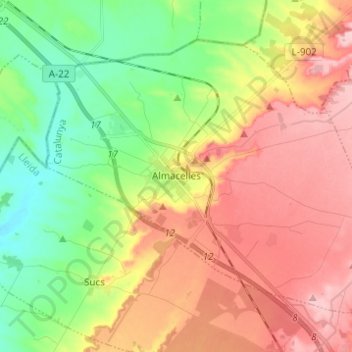
Name: Almacelles topographic map, elevation, terrain.
Location: Almacelles, Segriá, Cataluña, 25100, España (41.69365 0.39494 41.76505 0.51809)
Average elevation: 255 m
Minimum elevation: 177 m
Maximum elevation: 340 m
Thank you for supporting this site ❤️
Make a donation
Make a donation
Other topographic maps
Click on a map to view its topography, its elevation and its terrain.