
Thank you for supporting this site ❤️
Make a donation
Make a donation
Ciwaruga topographic map
Click on the map to display elevation.
Thank you for supporting this site ❤️
Make a donation
Make a donation
About this map
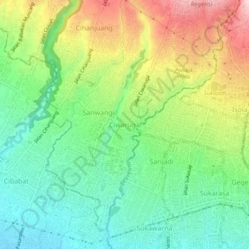
Name: Ciwaruga topographic map, elevation, terrain.
Location: Ciwaruga, Bandung, West Java, Java, 40559, Indonesia (-6.88138 107.56171 -6.84138 107.60171)
Average elevation: 893 m
Minimum elevation: 771 m
Maximum elevation: 1,070 m
Thank you for supporting this site ❤️
Make a donation
Make a donation
Other topographic maps
Click on a map to view its topography, its elevation and its terrain.
Thank you for supporting this site ❤️
Make a donation
Make a donation