
Thank you for supporting this site ❤️
Make a donation
Make a donation
Bluewater topographic map
Click on the map to display elevation.
Thank you for supporting this site ❤️
Make a donation
Make a donation
About this map
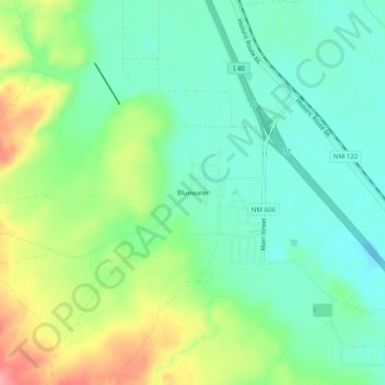
Name: Bluewater topographic map, elevation, terrain.
Location: Bluewater, Cibola County, New Mexico, 87005, United States (35.23503 -108.00562 35.27503 -107.96562)
Average elevation: 2,038 m
Minimum elevation: 2,003 m
Maximum elevation: 2,108 m
Thank you for supporting this site ❤️
Make a donation
Make a donation
Other topographic maps
Click on a map to view its topography, its elevation and its terrain.
El Malpais National Conservation Area
United States > New Mexico > Cibola County
Average elevation: 2,256 m