
Thank you for supporting this site ❤️
Make a donation
Make a donation
Oferdingen topographic map
Click on the map to display elevation.
Thank you for supporting this site ❤️
Make a donation
Make a donation
About this map
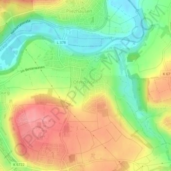
Name: Oferdingen topographic map, elevation, terrain.
Average elevation: 343 m
Minimum elevation: 294 m
Maximum elevation: 394 m
Thank you for supporting this site ❤️
Make a donation
Make a donation
Other topographic maps
Click on a map to view its topography, its elevation and its terrain.
Sickenhausen
Deutschland > Baden-Württemberg > Landkreis Reutlingen > Reutlingen
Average elevation: 370 m
Degerschlacht
Deutschland > Baden-Württemberg > Landkreis Reutlingen > Reutlingen
Average elevation: 376 m
Gönningen
Deutschland > Baden-Württemberg > Landkreis Reutlingen > Reutlingen
Average elevation: 608 m