
Thank you for supporting this site ❤️
Make a donation
Make a donation
Lawford topographic map
Click on the map to display elevation.
Thank you for supporting this site ❤️
Make a donation
Make a donation
About this map
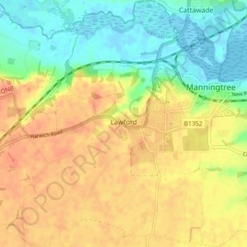
Name: Lawford topographic map, elevation, terrain.
Location: Lawford, Tendring, Essex, England, United Kingdom (51.91814 1.00496 51.95963 1.06195)
Average elevation: 23 m
Minimum elevation: -4 m
Maximum elevation: 43 m
Thank you for supporting this site ❤️
Make a donation
Make a donation
Other topographic maps
Click on a map to view its topography, its elevation and its terrain.
Thank you for supporting this site ❤️
Make a donation
Make a donation
Thank you for supporting this site ❤️
Make a donation
Make a donation
Wivenhoe Woods
United Kingdom > England > Essex > Colchester > Wivenhoe > Rowhedge
Average elevation: 18 m
Thank you for supporting this site ❤️
Make a donation
Make a donation