Geolocate

Brookhouse topographic map

Click on the map to display elevation.

About this map

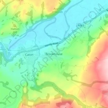
Name: Brookhouse topographic map, elevation, terrain.

Location: Brookhouse, Lancaster, Lancashire, England, LA2 9PA, United Kingdom (54.05490 -2.72331 54.09490 -2.68331)

Average elevation: 82 m

Minimum elevation: 11 m

Maximum elevation: 224 m

Other topographic maps

Click on a map to view its topography, its elevation and its terrain.

Morecambe

United Kingdom > England > Lancashire > Lancaster

Average elevation: 3 m

Overton

United Kingdom > England > Lancashire > Lancaster

Average elevation: 10 m

Ireby

United Kingdom > England > Lancashire > Lancaster

Average elevation: 218 m

Morecambe

United Kingdom > England > Lancashire > Lancaster

Average elevation: 3 m

Over Kellet

United Kingdom > England > Lancashire > Lancaster

Average elevation: 69 m

Silverdale

United Kingdom > England > Lancashire > Lancaster

Average elevation: 16 m

Wennington

United Kingdom > England > Lancashire > Lancaster > Wennington

Average elevation: 71 m

Carnforth

United Kingdom > England > Lancashire > Lancaster

Average elevation: 28 m

Warton

United Kingdom > England > Lancashire > Lancaster

Average elevation: 21 m

Middleton

United Kingdom > England > Lancashire > Lancaster

Average elevation: 5 m

Cockerham

United Kingdom > England > Lancashire > Lancaster

Average elevation: 8 m

Quernmore

United Kingdom > England > Lancashire > Lancaster

Average elevation: 131 m