
Harrogate topographic map
Interactive map
Click on the map to display elevation.
About this map
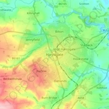
Name: Harrogate topographic map, elevation, terrain.
Average elevation: 106 m
Minimum elevation: 40 m
Maximum elevation: 221 m
Other topographic maps
Click on a map to view its topography, its elevation and its terrain.
Catterick
Verenigd Koninkrijk > Engeland > North Yorkshire
Catterick, North Yorkshire, Engeland, Verenigd Koninkrijk
Average elevation: 61 m
Bedale
Verenigd Koninkrijk > Engeland > North Yorkshire > Hambleton > Aiskew
Bedale, Aiskew, Hambleton, North Yorkshire, Engeland, Verenigd Koninkrijk
Average elevation: 46 m
Harrogate
Verenigd Koninkrijk > Engeland > North Yorkshire
Harrogate, North Yorkshire, Engeland, Verenigd Koninkrijk
Average elevation: 131 m
Lothersdale
Verenigd Koninkrijk > Engeland > North Yorkshire > Craven > Lothersdale
Lothersdale, Craven, North Yorkshire, Yorkshire and the Humber, Engeland, BD20, Verenigd Koninkrijk
Average elevation: 265 m