
Make a donation
Buryatia topographic map
Click on the map to display elevation.
Make a donation
About this map
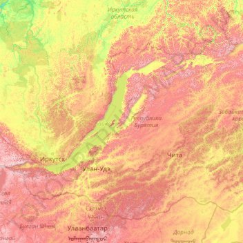
Name: Buryatia topographic map, elevation, terrain.
Location: Buryatia, Far Eastern Federal District, Russia (49.96978 98.62992 57.24988 116.92173)
Average elevation: 923 m
Minimum elevation: 160 m
Maximum elevation: 3,152 m
Make a donation
Other topographic maps
Click on a map to view its topography, its elevation and its terrain.
Oymyakon
Russia > Sakha Republic > Oymyakonsky Ulus
With an extreme subarctic climate (Köppen climate classification Dfd, Trewartha climate classification Ecle), Oymyakon is known as one of the places considered the Northern Pole of Cold, the other being the town of Verkhoyansk, located 629 km (391 mi) away by air. The weather station is in a valley between…
Average elevation: 679 m
Kamensk-Uralsky
Russia > Sverdlovsk Oblast > городской округ Каменск-Уральский > Kamensk-Uralsky
Average elevation: 173 m
Yekaterinburg
Russia > Sverdlovsk Oblast > Yekaterinburg Municipality > Yekaterinburg
Average elevation: 274 m
Make a donation
Make a donation