
Thank you for supporting this site ❤️
Make a donation
Make a donation
Fayetteville topographic map
Click on the map to display elevation.
Thank you for supporting this site ❤️
Make a donation
Make a donation
Fayetteville
...yet I venture the assertion that nowhere in said country—or for that matter, in any part of the state—could be found a lovelier elevation, or a lovelier grove of graceful oaks, or a more commanding view, or, in fine, a spot better suited and adapted for the purposes designated than the one chosen for said University site and farm.
Thank you for supporting this site ❤️
Make a donation
Make a donation
About this map
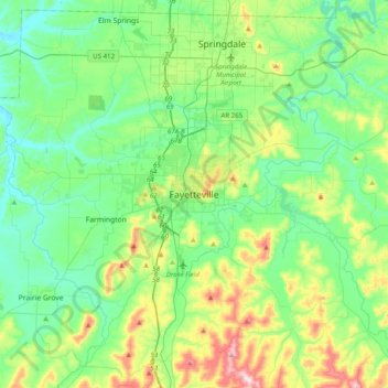
Name: Fayetteville topographic map, elevation, terrain.
Average elevation: 404 m
Minimum elevation: 310 m
Maximum elevation: 674 m
Thank you for supporting this site ❤️
Make a donation
Make a donation