
Thank you for supporting this site ❤️
Make a donation
Make a donation
Fishpond topographic map
Click on the map to display elevation.
Thank you for supporting this site ❤️
Make a donation
Make a donation
About this map
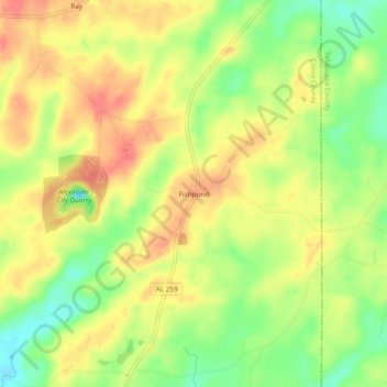
Name: Fishpond topographic map, elevation, terrain.
Location: Fishpond, Coosa County, Alabama, United States (32.84790 -86.04330 32.88790 -86.00330)
Average elevation: 206 m
Minimum elevation: 172 m
Maximum elevation: 233 m
Thank you for supporting this site ❤️
Make a donation
Make a donation
Other topographic maps
Click on a map to view its topography, its elevation and its terrain.