
Lunan topographic map
Interactive map
Click on the map to display elevation.
About this map
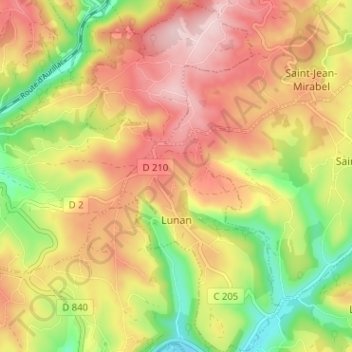
Name: Lunan topographic map, elevation, terrain.
Average elevation: 308 m
Minimum elevation: 169 m
Maximum elevation: 428 m
Other topographic maps
Click on a map to view its topography, its elevation and its terrain.
Les Martres
France > Occitanie > Lot > Le Bourg
Les Martres, Le Bourg, Figeac, Lot, Occitanie, France métropolitaine, 46120, France
Average elevation: 388 m
Latuque
France > Occitanie > Lot > Montcabrier
Latuque, Montcabrier, Cahors, Lot, Occitanie, France métropolitaine, 46700, France
Average elevation: 228 m
Rocamadour
France > Occitanie > Lot > Rocamadour
Rocamadour, Gourdon, Lot, Occitanie, France métropolitaine, 46500, France
Average elevation: 247 m
Saint-Cirq-Souillaguet
Saint-Cirq-Souillaguet, Gourdon, Lot, Occitanie, France métropolitaine, 46300, France
Average elevation: 317 m