
Make a donation
Britten topographic map
Click on the map to display elevation.
Make a donation
About this map
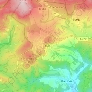
Name: Britten topographic map, elevation, terrain.
Average elevation: 367 m
Minimum elevation: 231 m
Maximum elevation: 516 m
Make a donation
Other topographic maps
Click on a map to view its topography, its elevation and its terrain.
Niederlosheim
Deutschland > Saarland > Landkreis Merzig-Wadern > Losheim am See
Average elevation: 313 m
Stausee Losheim
Deutschland > Saarland > Landkreis Merzig-Wadern > Losheim am See
Average elevation: 331 m
Make a donation
Waldhölzbach
Deutschland > Saarland > Landkreis Merzig-Wadern > Losheim am See
Average elevation: 440 m
Rissenthal
Deutschland > Saarland > Landkreis Merzig-Wadern > Losheim am See
Rissenthal liegt an einem südlichen Ausläufer des Schwarzwälder Hochwaldes, in einem Seitental des Oberen Haustadter Tales, südsüdöstlich vom Kern der Gemeinde Losheim. Die durchschnittliche Höhe liegt bei 250 m ü. NHN. Die das Dorf umgebenden Höhen erreichen mit dem Schlädberg auf 382 m ü. NHN die…
Average elevation: 316 m
Make a donation
Make a donation