
La Bethaz topographic map
Interactive map
Click on the map to display elevation.
About this map
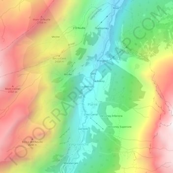
Name: La Bethaz topographic map, elevation, terrain.
Location: La Bethaz, Planté, Valgrisenche, Valle d'Aosta, Italia (45.62448 7.04734 45.66448 7.08734)
Average elevation: 2,188 m
Minimum elevation: 1,509 m
Maximum elevation: 3,037 m
Other topographic maps
Click on a map to view its topography, its elevation and its terrain.
Chez Carral
Italia > Valle d'Aosta > Planté
Chez Carral, Planté, Valgrisenche, Valle d'Aosta, Italia
Average elevation: 2,206 m