
Thank you for supporting this site ❤️
Make a donation
Make a donation
Tanza topographic map
Click on the map to display elevation.
Thank you for supporting this site ❤️
Make a donation
Make a donation
About this map
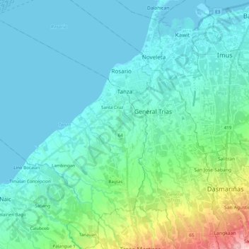
Name: Tanza topographic map, elevation, terrain.
Location: Tanza, Cavite, Calabarzon, 4108, Philippines (14.28121 120.70877 14.47073 120.87583)
Average elevation: 28 m
Minimum elevation: -1 m
Maximum elevation: 179 m
Thank you for supporting this site ❤️
Make a donation
Make a donation
Other topographic maps
Click on a map to view its topography, its elevation and its terrain.