
Thank you for supporting this site ❤️
Make a donation
Make a donation
Alliance topographic map
Click on the map to display elevation.
Thank you for supporting this site ❤️
Make a donation
Make a donation
About this map
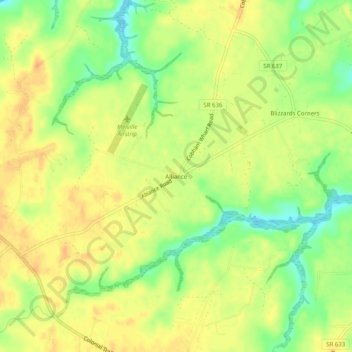
Name: Alliance topographic map, elevation, terrain.
Location: Alliance, Surry County, Virginia, 23883, United States (37.11820 -76.80357 37.15820 -76.76357)
Average elevation: 24 m
Minimum elevation: 1 m
Maximum elevation: 38 m
Thank you for supporting this site ❤️
Make a donation
Make a donation
Other topographic maps
Click on a map to view its topography, its elevation and its terrain.