
Thank you for supporting this site ❤️
Make a donation
Make a donation
Karakuyu topographic map
Click on the map to display elevation.
Thank you for supporting this site ❤️
Make a donation
Make a donation
About this map
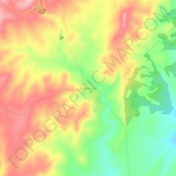
Name: Karakuyu topographic map, elevation, terrain.
Location: Karakuyu, Uşak, Aegean Region, Turkey (38.74029 29.09271 38.78029 29.13271)
Average elevation: 767 m
Minimum elevation: 654 m
Maximum elevation: 871 m
Thank you for supporting this site ❤️
Make a donation
Make a donation
Other topographic maps
Click on a map to view its topography, its elevation and its terrain.