
Make a donation
La Palma topographic map
Click on the map to display elevation.
Make a donation
La Palma
La Palma can be characterized by two main climate types: The Mediterranean climate (Köppen : Csb/Csa), characterized by dry summers and humid winters, is prevalent in the northern coast and in the mid to high altitudes of the island. At lower altitudes, particularly at the south and southwest coasts, the climate becomes semi-arid (Köppen : BSh). Average temperatures at the coast vary from 18 °C (64 °F) in January and February to 24 °C (75 °F) in August and September. For a Canary island, the weather is quite cloudy, as La Palma is far more exposed to marine air systems than easterly islands, caused by the Canary Current. As altitude increases moving inland, the climate becomes cooler and more humid, which provides conditions for laurisilva cloud forests to occur, such as the one in the Natural Park of Bosque de los Tiles.
Make a donation
About this map
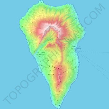
Name: La Palma topographic map, elevation, terrain.
Location: La Palma, Santa Cruz de Tenerife, Canary Islands, Spain (28.45271 -18.00725 28.85754 -17.72422)
Average elevation: 296 m
Minimum elevation: 0 m
Maximum elevation: 2,410 m
Make a donation
Other topographic maps
Click on a map to view its topography, its elevation and its terrain.