
Thank you for supporting this site ❤️
Make a donation
Make a donation
Le Thoronet topographic map
Click on the map to display elevation.
Thank you for supporting this site ❤️
Make a donation
Make a donation
About this map
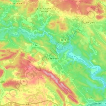
Name: Le Thoronet topographic map, elevation, terrain.
Average elevation: 205 m
Minimum elevation: 62 m
Maximum elevation: 428 m
Thank you for supporting this site ❤️
Make a donation
Make a donation
Other topographic maps
Click on a map to view its topography, its elevation and its terrain.
Lotissement "Les Hameaux du Golf"
Frankrijk > Provence-Alpes-Côte d'Azur > Var > Sainte-Maxime
Average elevation: 80 m
Les Mas de Guerrevieille
Frankrijk > Provence-Alpes-Côte d'Azur > Var > Sainte-Maxime
Average elevation: 60 m
Paris Plage
Frankrijk > Provence-Alpes-Côte d'Azur > Var > Sainte-Maxime > Gauthier-Haut
Average elevation: 22 m
Thank you for supporting this site ❤️
Make a donation
Make a donation
Saint-Jean de l'Esterel
Frankrijk > Provence-Alpes-Côte d'Azur > Var > Fréjus
Average elevation: 259 m
Les Mas de Mathurine
Frankrijk > Provence-Alpes-Côte d'Azur > Var > Montferrat
Average elevation: 802 m