
Petite-Île topographic map
Interactive map
Click on the map to display elevation.
About this map
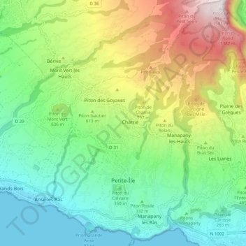
Name: Petite-Île topographic map, elevation, terrain.
Location: Petite-Île, Saint-Pierre, La Réunion, 97429, France (-21.37814 55.53581 -21.28784 55.60558)
Average elevation: 524 m
Minimum elevation: 0 m
Maximum elevation: 1,579 m
Other topographic maps
Click on a map to view its topography, its elevation and its terrain.
Manapany les Bas
France > La Réunion > Petite-Île
Manapany les Bas, Petite-Île, Saint-Pierre, La Réunion, 97429, France
Average elevation: 157 m
Charrié
France > La Réunion > Petite-Île
Charrié, Petite-Île, Saint-Pierre, La Réunion, 97429, France
Average elevation: 614 m