
Thank you for supporting this site ❤️
Make a donation
Make a donation
Farlinville topographic map
Click on the map to display elevation.
Thank you for supporting this site ❤️
Make a donation
Make a donation
About this map
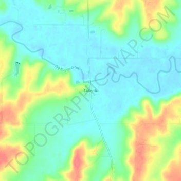
Name: Farlinville topographic map, elevation, terrain.
Location: Farlinville, Linn County, Kansas, United States (38.21336 -94.87385 38.25336 -94.83385)
Average elevation: 267 m
Minimum elevation: 246 m
Maximum elevation: 306 m
Thank you for supporting this site ❤️
Make a donation
Make a donation
Other topographic maps
Click on a map to view its topography, its elevation and its terrain.
Thank you for supporting this site ❤️
Make a donation
Make a donation
Thank you for supporting this site ❤️
Make a donation
Make a donation
Blue Mound
United States > Kansas > Linn County
Blue Mound was laid out in 1882. It was named by its first postmaster, John Q. Adams, because its elevation is said to look blue from a distance.
Average elevation: 322 m