
Thank you for supporting this site ❤️
Make a donation
Make a donation
Hornelen topographic map
Click on the map to display elevation.
Thank you for supporting this site ❤️
Make a donation
Make a donation
Hornelen
The horizontal distance from the summit to the sea is approximately 500 metres (1,600 ft). Approximately 1 kilometre (0.62 mi) to the west of the cliffside is the highest point on the island Bremangerlandet, called Svartevassegga which has an elevation of 889 metres (2,917 ft). The rock in Hornelen consists of sandstone of Devonian age, and it constitutes an important part of the geology of Norway.
Thank you for supporting this site ❤️
Make a donation
Make a donation
About this map
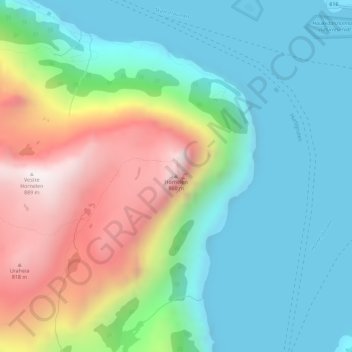
Name: Hornelen topographic map, elevation, terrain.
Location: Hornelen, Bremanger, Vestland, 6719, Norway (61.85578 5.24691 61.85588 5.24701)
Average elevation: 282 m
Minimum elevation: 0 m
Maximum elevation: 886 m
Thank you for supporting this site ❤️
Make a donation
Make a donation
Other topographic maps
Click on a map to view its topography, its elevation and its terrain.
Thank you for supporting this site ❤️
Make a donation
Make a donation
Thank you for supporting this site ❤️
Make a donation
Make a donation
Thank you for supporting this site ❤️
Make a donation
Make a donation
Thank you for supporting this site ❤️
Make a donation
Make a donation
Thank you for supporting this site ❤️
Make a donation
Make a donation
Thank you for supporting this site ❤️
Make a donation
Make a donation
Thank you for supporting this site ❤️
Make a donation
Make a donation
Thank you for supporting this site ❤️
Make a donation
Make a donation
Thank you for supporting this site ❤️
Make a donation
Make a donation
Thank you for supporting this site ❤️
Make a donation
Make a donation
Thank you for supporting this site ❤️
Make a donation
Make a donation
Thank you for supporting this site ❤️
Make a donation
Make a donation