Geolocate

Kattachira topographic map

Click on the map to display elevation.

About this map

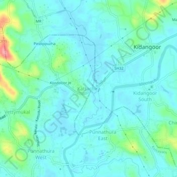
Name: Kattachira topographic map, elevation, terrain.

Location: Kattachira, Kottayam, Kerala, 686572, India (9.65514 76.57696 9.69514 76.61696)

Average elevation: 20 m

Minimum elevation: 1 m

Maximum elevation: 101 m

Other topographic maps

Click on a map to view its topography, its elevation and its terrain.

Manimala River

India > Kerala > Kottayam > Eravinalloor

Average elevation: 12 m

child

India > Kerala > Kottayam > Thiruvanchoor

Average elevation: 13 m

Kanjikuzhy

India > Kerala > Kottayam > Manganam

Average elevation: 14 m

Meenachil

India > Kerala > Kottayam > Pulikuttisseri

Average elevation: 7 m

Alapuzha

India > Kerala > Kottayam > Kottayam

Average elevation: 10 m

Meenadom

India > Kerala > Kottayam > Pariyaram

Average elevation: 36 m

Alapuzha

India > Kerala > Kottayam > Kottayam

Average elevation: 10 m

Sankranthi

India > Kerala > Kottayam > Kottayam

Average elevation: 15 m

Alapuzha

India > Kerala > Kottayam > Kottayam

Average elevation: 10 m

Karapuzha

India > Kerala > Kottayam > Kottayam

Average elevation: 7 m