
Make a donation
Potrero Poi topographic map
Click on the map to display elevation.
Make a donation
About this map
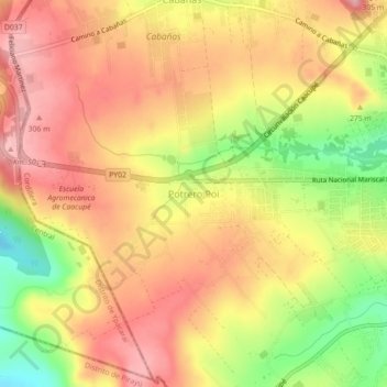
Name: Potrero Poi topographic map, elevation, terrain.
Average elevation: 242 m
Minimum elevation: 150 m
Maximum elevation: 301 m
Make a donation
Other topographic maps
Click on a map to view its topography, its elevation and its terrain.
Altos
Paraguay > Cordillera Department
It is also called “Altos de Ybypytaré”, which in Guaraní means “path of the wind”, previously called “San Lorenzo de la Cordillera de los Altos”, one of the oldest cities of Paraguay. It is known as the “Terrace of the country” because of its high altitude.
Average elevation: 208 m
Altos
Paraguay > Cordillera Department
It is also called "Altos de Ybypytaré", which in Guaraní means "path of the wind", previously called "San Lorenzo de la Cordillera de los Altos", one of the oldest cities of Paraguay. It is known as the "Terrace of the country" because of its high altitude.
Average elevation: 208 m
Make a donation
Make a donation