
Kaslo topographic map
Click on the map to display elevation.
About this map
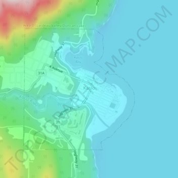
Name: Kaslo topographic map, elevation, terrain.
Average elevation: 591 m
Minimum elevation: 518 m
Maximum elevation: 946 m
Other topographic maps
Click on a map to view its topography, its elevation and its terrain.
Halcyon
Canada > British Columbia > Regional District of Central Kootenay > Area K (The Arrow Lakes)
Average elevation: 721 m
Mount Cooper
Canada > British Columbia > Regional District of Central Kootenay > Area D (Lardeau Valley/Duncan Lake)
Average elevation: 2,481 m
Blewett
Canada > British Columbia > Regional District of Central Kootenay > Area E (Balfour/Cottonwood Lake) > Blewett
Average elevation: 837 m
Mount Stanley
Canada > British Columbia > Regional District of Central Kootenay > Area J (Lower Arrow/Columbia)
Average elevation: 1,978 m