
Thank you for supporting this site ❤️
Make a donation
Make a donation
Wassenberg topographic map
Click on the map to display elevation.
Thank you for supporting this site ❤️
Make a donation
Make a donation
About this map
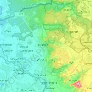
Name: Wassenberg topographic map, elevation, terrain.
Average elevation: 59 m
Minimum elevation: 27 m
Maximum elevation: 150 m
Thank you for supporting this site ❤️
Make a donation
Make a donation
Other topographic maps
Click on a map to view its topography, its elevation and its terrain.
Kleingladbach
Germany > North Rhine-Westphalia > Kreis Heinsberg > Hückelhoven
Average elevation: 84 m
Wahnenbusch
Germany > North Rhine-Westphalia > Kreis Heinsberg > Erkelenz > Tenholt
Average elevation: 94 m
Thank you for supporting this site ❤️
Make a donation
Make a donation
Auf dem Wengel
Germany > North Rhine-Westphalia > Kreis Heinsberg > Wegberg > Büch
Average elevation: 79 m
Thank you for supporting this site ❤️
Make a donation
Make a donation
Hückelhoven
Germany > North Rhine-Westphalia > Kreis Heinsberg > Hückelhoven > Hückelhoven
Average elevation: 69 m
Thank you for supporting this site ❤️
Make a donation
Make a donation