
Thank you for supporting this site ❤️
Make a donation
Make a donation
Jacobsburg topographic map
Click on the map to display elevation.
Thank you for supporting this site ❤️
Make a donation
Make a donation
About this map
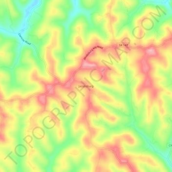
Name: Jacobsburg topographic map, elevation, terrain.
Location: Jacobsburg, Belmont County, Ohio, 43933, United States (39.94507 -80.92426 39.98507 -80.88426)
Average elevation: 356 m
Minimum elevation: 282 m
Maximum elevation: 418 m
Thank you for supporting this site ❤️
Make a donation
Make a donation
Other topographic maps
Click on a map to view its topography, its elevation and its terrain.
Thank you for supporting this site ❤️
Make a donation
Make a donation
Thank you for supporting this site ❤️
Make a donation
Make a donation
Thank you for supporting this site ❤️
Make a donation
Make a donation