
Thank you for supporting this site ❤️
Make a donation
Make a donation
Halheim topographic map
Click on the map to display elevation.
Thank you for supporting this site ❤️
Make a donation
Make a donation
About this map
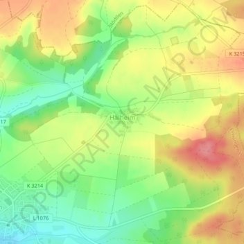
Name: Halheim topographic map, elevation, terrain.
Average elevation: 524 m
Minimum elevation: 482 m
Maximum elevation: 566 m
Thank you for supporting this site ❤️
Make a donation
Make a donation
Other topographic maps
Click on a map to view its topography, its elevation and its terrain.
Haisterhofen
Deutschland > Baden-Württemberg > Ostalbkreis > Ellwangen (Jagst)
Average elevation: 479 m
Hinterlengenberg
Deutschland > Baden-Württemberg > Ostalbkreis > Ellwangen (Jagst)
Average elevation: 487 m
Thank you for supporting this site ❤️
Make a donation
Make a donation
Hochgreut
Deutschland > Baden-Württemberg > Ostalbkreis > Ellwangen (Jagst) > Pfahlheim
Average elevation: 507 m