
Arniquet topographic map
Interactive map
Click on the map to display elevation.
About this map
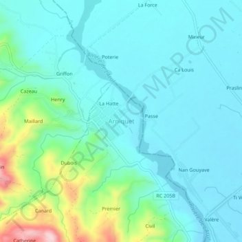
Name: Arniquet topographic map, elevation, terrain.
Average elevation: 63 m
Minimum elevation: 7 m
Maximum elevation: 294 m
Other topographic maps
Click on a map to view its topography, its elevation and its terrain.
Fouron
Haïti > Département du Sud > Commune Port-Salut
Fouron, 1re Barbois, Commune Port-Salut, Arrondissement Port-Salut, Département du Sud, Haïti
Average elevation: 170 m
Morne Jet d'Eau
Haïti > Département du Sud > Commune Port-Salut
Morne Jet d'Eau, Commune Port-Salut, Arrondissement Port-Salut, Département du Sud, Haïti
Average elevation: 114 m