
Thank you for supporting this site ❤️
Make a donation
Make a donation
Upper Macopin topographic map
Click on the map to display elevation.
Thank you for supporting this site ❤️
Make a donation
Make a donation
About this map
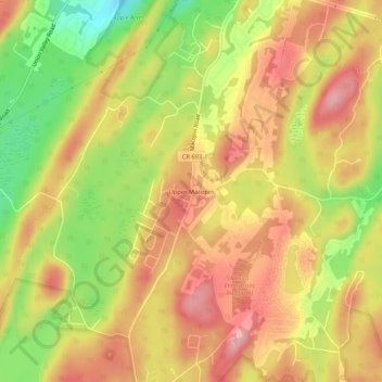
Name: Upper Macopin topographic map, elevation, terrain.
Average elevation: 298 m
Minimum elevation: 219 m
Maximum elevation: 353 m
Thank you for supporting this site ❤️
Make a donation
Make a donation
Other topographic maps
Click on a map to view its topography, its elevation and its terrain.
Abram S. Hewitt State Forest
United States > New Jersey > Passaic County > West Milford
Average elevation: 318 m