
Thank you for supporting this site ❤️
Make a donation
Make a donation
Notzingen topographic map
Click on the map to display elevation.
Thank you for supporting this site ❤️
Make a donation
Make a donation
About this map
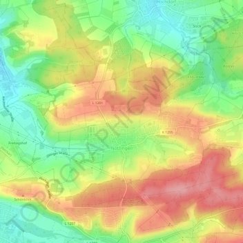
Name: Notzingen topographic map, elevation, terrain.
Average elevation: 335 m
Minimum elevation: 278 m
Maximum elevation: 391 m
Thank you for supporting this site ❤️
Make a donation
Make a donation
Other topographic maps
Click on a map to view its topography, its elevation and its terrain.
Egelsberg
Deutschland > Baden-Württemberg > Landkreis Esslingen > Weilheim an der Teck
Average elevation: 379 m
Hofgut Tachenhausen
Deutschland > Baden-Württemberg > Landkreis Esslingen > Oberboihingen
Average elevation: 321 m
Thank you for supporting this site ❤️
Make a donation
Make a donation