
Cambodia topographic map
Interactive map
Click on the map to display elevation.
About this map
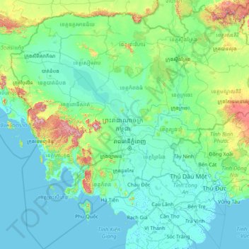
Name: Cambodia topographic map, elevation, terrain.
Location: Cambodia (9.45527 102.33383 14.69042 107.62768)
Average elevation: 99 m
Minimum elevation: -3 m
Maximum elevation: 1,685 m
Cambodia's landscape is characterised by a low-lying central plain that is surrounded by uplands and low mountains and includes the Tonle Sap (Great Lake) and the upper reaches of the Mekong River delta. Extending outward from this central region are transitional plains, thinly forested and rising to elevations of about 650 feet (200 metres) above sea level.
Other topographic maps
Click on a map to view its topography, its elevation and its terrain.
Sangkat Chak Angrae Kraom
Cambodia > Phnom Penh > Sangkat Chak Angrae Kraom
Sangkat Chak Angrae Kraom, Khan Mean Chey, Phnom Penh, 12353, Cambodia
Average elevation: 9 m