
Thank you for supporting this site ❤️
Make a donation
Make a donation
Allanton topographic map
Click on the map to display elevation.
Thank you for supporting this site ❤️
Make a donation
Make a donation
About this map
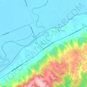
Name: Allanton topographic map, elevation, terrain.
Location: Allanton, Dunedin City, Otago, New Zealand (-45.93603 170.24443 -45.89603 170.28443)
Average elevation: 59 m
Minimum elevation: 0 m
Maximum elevation: 262 m
Thank you for supporting this site ❤️
Make a donation
Make a donation
Other topographic maps
Click on a map to view its topography, its elevation and its terrain.